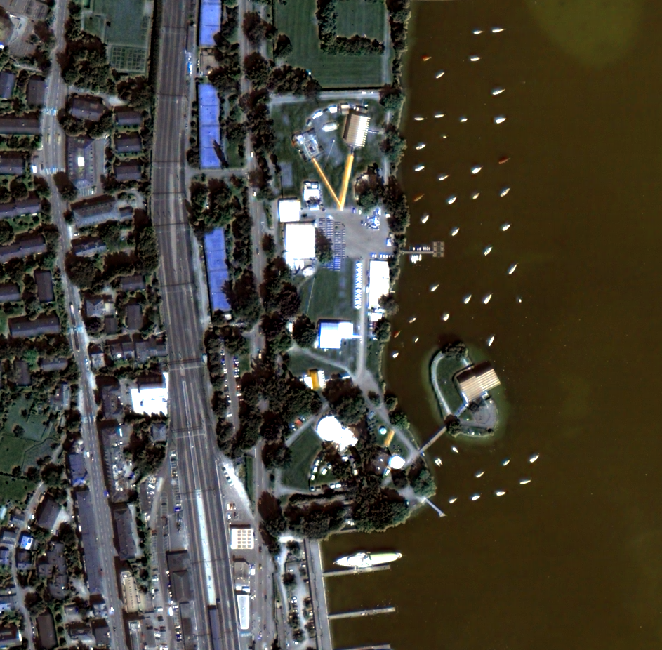
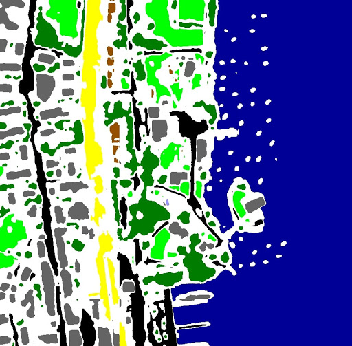
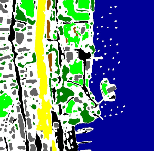
Satellite Image Segmentation using Deep Learning. Satellite images are one of the most powerful and important tools used by the meteorologist. They are essentially the eyes in the sky . Today advances in remote sensing technologies have made it possible to capture imagery with resolutions as high as 0.41 metres on earth. Today’s satellites have the power to ‘see’ and distinguish objects that are as little as 16 inches apart from one another on the ground. We have implemented a satellite image classification technique for satellite imagery that classify 8 eight classes namely Water, Grass ,Roads , Building , Trees , Swimming pool , Railway and Bare Soil.
As AutoEncoders are useful for noise filtering.Our UNet-model’s output has noise in it and and also classes that disconnected. Our KV-Net model uses this feature of autoencoders to reconnect the disconnected roads, railways,waters, and etc. which are mostly never disconnected in practice.
cv2
tifffile
numpy
keras-gpu
tensorflow-gpu
glob
We have implemented a satellite image classification technique for satellite imagery that classify 8 eight classes namely Water, Grass ,Roads , Building , Trees , Swimming pool , Railway and Bare Soil.
put you sat images in data/sat5band/ folder
run the following lines to train the model for all images(including newly added) again.
python3 edgeGen.py # this generates the edge data
python3 water_mask_function.py # this generates the water data
python3 Grass_mask_function.py # this generates the Vegetation data
python3 genpatches.py # to generate patches for above generated data
python3 train_unet.py # this will begin the training of unet model
python3 train_kvnet.py # Training of KV_Net
python3 predict_kvnet.py # Output will be stored in ./outputs/ of data/test/
Inorder to run it directly using weights saved download weights from here https://drive.google.com/file/d/10xldHiPczByAbWKMJ3Ov0uusbUY5Ve53/view?usp=sharing https://drive.google.com/file/d/1qXzXAAYm0G6z9SaiLtbc1vEqh3E-qS2N/view?usp=sharing
then run this command
python3 predict.py
python3 predict2.py
python3 predict_kvnet.py